

Attachments
If You click on any item from the following list it opens in a new tab (window); as when viewing from the full version. Then, all the attachments are displayed below - as figures and texts; ordered by numbers.
fig. 1 the first map of Rockall
fig. 2 Rockall, the view from the south
fig. 3 Rockall, the view from the north
fig. 4 Rockall, the view from the west
fig. 5 Rockall, the view from the south
fig. 6 approximate location of Rockall
fig. 7 the scheme of Rockall Plateau
fig. 8 the graph of the precipitation, the temperature of air and water
fig. 9 the graph of the wind speed
fig. 10 the surface-water currents
fig. 11 the deep-water currents
fig. 12 the origin of the water
fig. 13 the geological development of the Rockall Plateau
fig. 14 the geological development of the subsoil
fig. 1518 photography of the Rockall Bank
fig. 19 the occurrence of the coral on the Rockall Bank
fig. 20 the map, 1771
fig. 21 the painting of Rockall, 1811
fig. 22 the sketch of Rockall, 1810
fig. 23 the painting of Rockall, 1889
fig. 24 the steamer Norge
fig. 25 Pourquoi-Pas?
fig. 26 the plaque of the navigational beacon light, 1971
fig. 27 the visit by the Royal Navy, 1974
fig. 28 the protest action of Greenpeace, 1997
fig. 29 the air photo of the Greenpeace pod
fig. 30 the pod of Greenpeace inside
fig. 31 the Greenpeace activists
fig. 32 the flag of the state of Waveland
fig. 33 the Greenpeace activist before the action
fig. 34 the navigational beacon installed by Greenpeace in 1998
fig. 35 the sketch of the claims to the Rockall Plateau by the states
fig. 36 the change of the borders of the Exclusive Economic Zone of the United Kingdom
fig. 37 the historical map from the atlas by G. Mercator from 1618
fig. 39 the photo taken in 1971 during the cut-off of the summit of Rockall
text 1 the discovery of Rockall by Basil Hall
text 2 the Law of the Sea (an extract of the UN Conventions)
Figures
Here there are the figures attached to the work, from which they are linked. When you mouse over any figure, its number will show. To view the full-size picture please click on it.
fig. 1 the first map of Rockall Publisher in the 141st number of The Geographical Journal), March 1975; set by G. S. Holland and R. A. Gardiner according to the aerial photos by the Royal Air Force from the year 1970 (according to the authors it is not much precise; its orientation also not because of the magnetic anomalies).
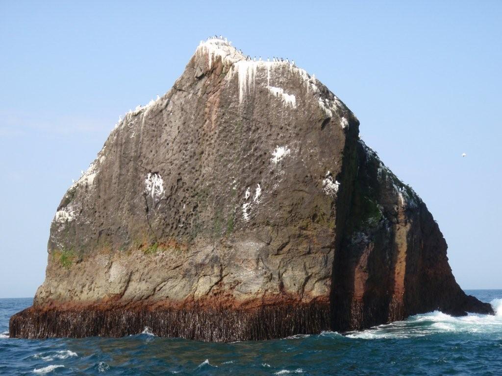
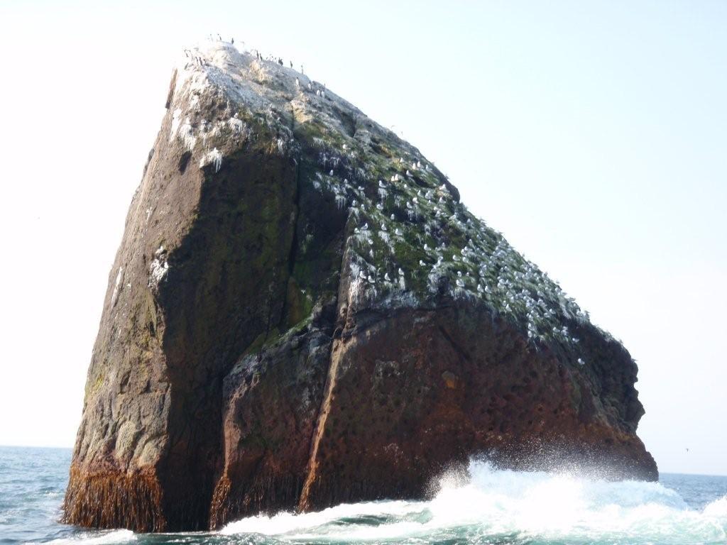


fig. 2 - 5 four horizontal views of Rockall, from the four wards (according to the little map) from the east, the north, the west and the south. On the fig. 4 there is visible Halls Ledge, on fig. 4-5 there is the broken navigational beacon. On fig. 2-5 there are showed colonies of birds and sea-weed. Notice the guano-layer. Author of the photos is Andy Strangeway.
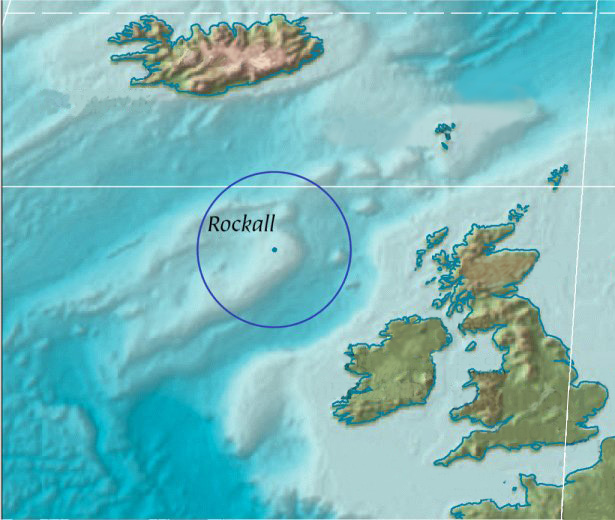
fig. 6 approximate location of Rockall
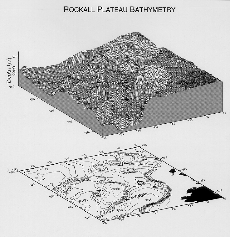
fig. 7 plastic scheme of the Rockall Plateau and Rockall Through with the map: In the south-east corner there is a part of Ireland; RB = Rockall Bank, FD = Feni Drift (Ridge), RT = Rockall Trough, FI = Faeroe Islands, HRB = Hatton-Rockall Basin, HB = Hatton Bank (according to the Ocean Drilling Program)
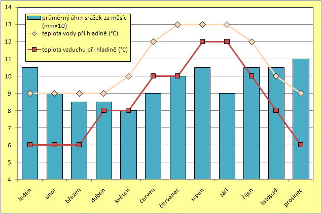

Months are listed chronologically from left to right (January to December).
fig. 8 graph of the precipitations and temperature in the area of Rockall: blue column shows the average quantity of the precipitations in 10s mm per month; the orange line shows the temperature of the water by the sea-level in °C; the red line show the temperature of the wind by the sea-level in °C (according to Atlas okeanov, 1977)fig. 9 graph of the wind-speed in the area of Rockall: red line shows the maximum (m per second); the blue line shows the average (according to Atlas okeanov, 1977)
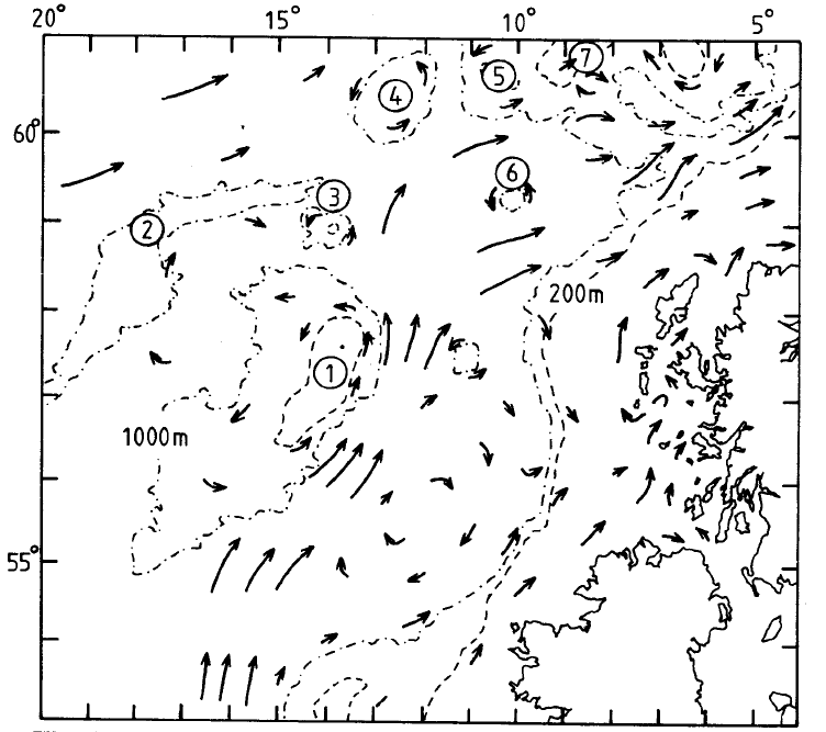
fig. 10 the surface-water currents nearby the Great Britain (1 Rockall Bank; 2 Hatton Bank; 3 George Bligh Bank; 4 Lousy Bank; 5 Bill Baileys Bank; 6 Rosemary Bank; 7 Faeroe Bank; Blacker, 1982)
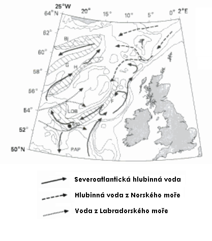
fig. 11 the deep-water currents of the Rockall Through and the Rockall Plateau with the origin: strong black line shows the North Atlantic deep-water, dashed line the Norwegian deep-water, the solid line shows the water from the Labrador Sea (LOB Lorien Bank; PAP Porcupine Abyssal Plain; Stroker, 1998)
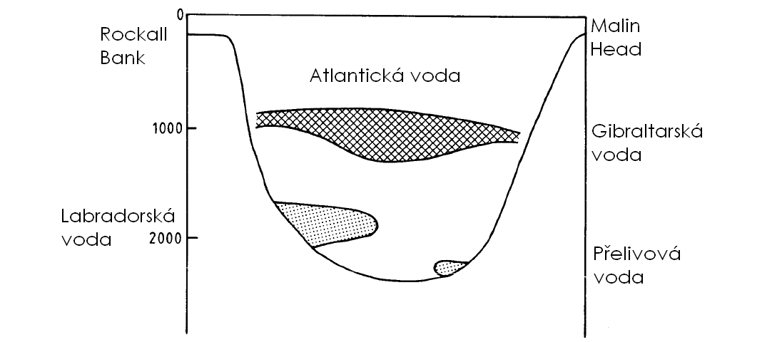
fig. 12 the scheme of the origin of the water in the Rockall Through: dotted area on the left-bottom is the Labradorean water, the dotted area on the right-bottom is the overflow water, the crossed area is the Gibraltarian water and the rest is the Atlantic water (east-west; Blacker, 1982)

fig. 13 simplified sketches of sea-floor spreading of the British Isles since the end of the Jurassic (a) At the end of the Jurassic, an emerged Precambrian crustal area (the Rockall, R, microcontinent) lay between Ireland and Greenland, Sea-floor spreading began between Iberia and Newfoundland, developing a fracture zone from the Pyrenees to the Labrador Sea. (b) Early to mid-Cretaceous sea-floor spreading separated Rockall from the British shelf but was aborted, leaving the Rockall Through (RT). (c) A triple junction appears off the Bay of Biscay in the early Senonian (80Ma), and Spain begins to rotate. (d) In the Paleocene (60-65 Ma) a new spreading center begins to separate the Rockall microcontinent from Greenland. (cited from Moores, 1997)

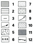 fig. 14 Gross depositional environment maps summarizing the main depositional systems existing during the development of the mid- to late Cenozoic megasequences. Key to symbols: 1, mounded, elongate sediment drift; 2, sheeted sediment drift; 3, sediment waves; 4, bottom-current circulation, inferred in (a), present-day in (b); 5, late Eoceneearliest Oligocene lowstand fan; 6, early Oligocene reef; 7, mid-Miocene to Holocene fans; 8, interbedded drift and downslope deposits; 9, sediment-source areas; 10, Inferred land areas; 11, areas of extensive bottom-current erosion; 12, maximum extent of mid- to late Pleistocene ice-sheets. Abbreviations: HS Hebridean shelf; RT Rockall Through; IB Iceland Basin; HB Hatton Bank; HRB Hatton-Rockall Basin; RKB Rockall Bank; GBB George Bligh Bank; LB Lousy Bank; AD undersea mountain Anton-Dohrn; BBB Bill Baileys Bank; FB Faeroe Bank, FS Faeroe Shelf; WTR Wyville-Thomson Ridge; RB Rosemary Bank; a - Eocene/Oligocene, b Miocene/Holocene (cited from Stroker, 1998)
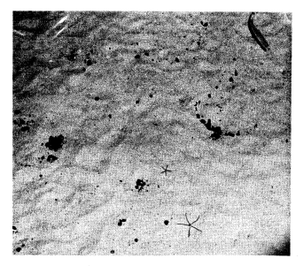
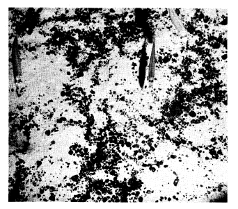

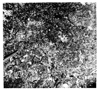
Photograph of the sea bed on Rockall Bank between 135 and 165 m depth. The picture area is about 1 square metre, and all the fish are lesser silver smelts (argentina sphyraena). (Blacker, 1982)
fig. 15 Fine coral sand with a few small pebbles. Two Brittle-stars (ophiuroid) can be seen;
fig. 16 Fine coral sand and pebbles;
fig. 17 Sand and stones. The stones support a fauna of sponges and other animals;
fig. 18 Rock and stones. Small colonies of coral and sponges are growing on the rocks.

fig. 19 Rockall Bank showing the distribution of the coral, Lophelia pertusa (c) (Blacker, 1982)
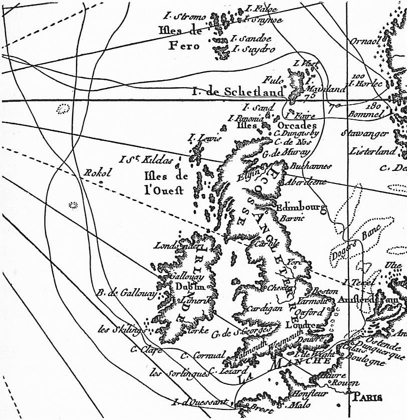
fig. 20 map of Britain from 1771 by French sailor Kerguelen

fig. 21 sketch showing the first landing on Rockall in 1811
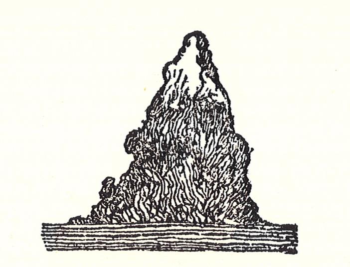
fig. 22 sketch by T. Harvey, Captain of HMS Enymion, showing Rockall during the discovery in 1810
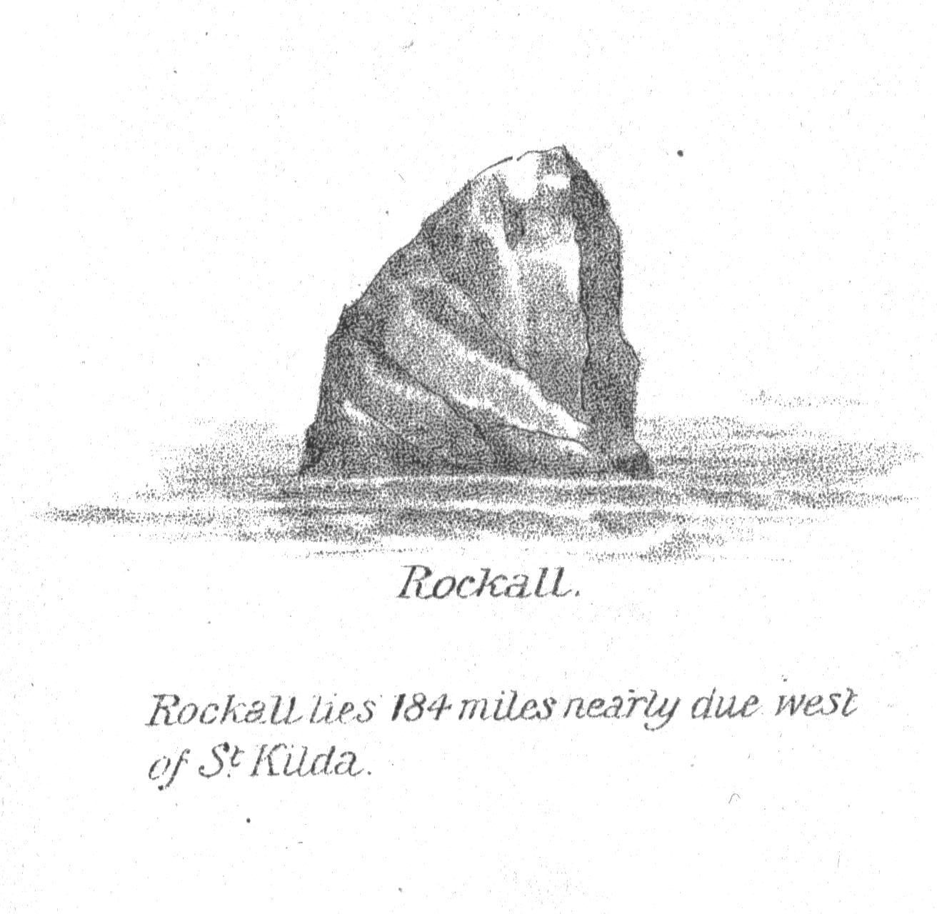
fig. 23 sketch of Rockall on the 81st page in the book A Vertebrate Fauna of the Outer Hebrides (J. A. Harvey-Brown & T. E. Buckley, 1889

fig. 24 Danish steamer Norge, which wrecked on the Helens Reef in 1904 635 lives perished

fig. 25 postcard from the expedition on Rockall of French ship Pourquoi-Pas? sponsored by the French Ministry for Navy in 1921
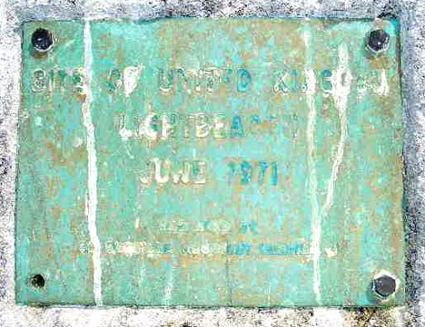
fig. 26 plaque fastened to the rock during the installation of a navigational beton:
Site of United Kingdom
Light Beacon
June 1971
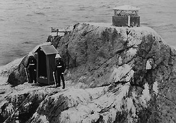
fig. 27 security pod with the flag of the Royal Navy and with two marines in full ceremonial dress; a navigational beacon above them
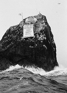
obr. 28 the view of the rock during the stage of four volunteers from Greenpeace sign United Nations No new oil; above the sign their solar pod; above that there is the flag of Waveland and the beacon
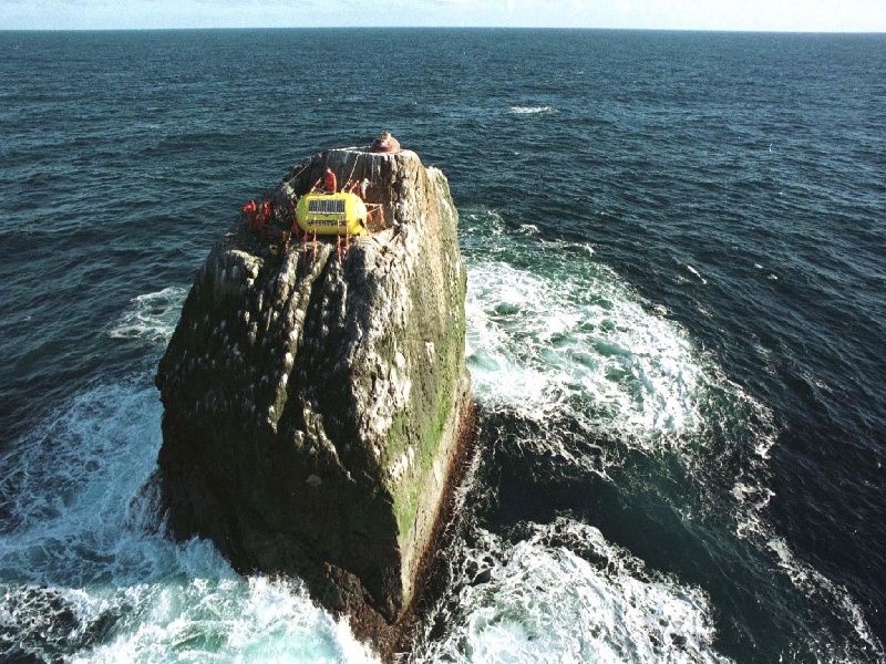
obr. 29 birds eye view

fig. 30 two activists inside the pod
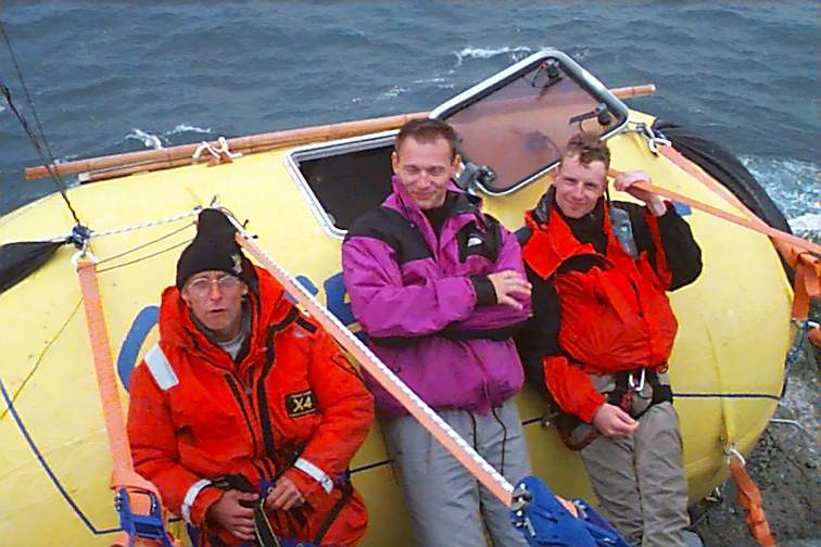
fig. 31 the security pod and its fixation to the rock (by twelve six-tonnes straps), with the three of volunteers

fig. 32 flag of Waveland hoisted on Rockall, during the times of good weather

fig. 33 our activists from Greenpeace (from left: Al Baker, David Sims, Peter (?) and Meike Huelsman) before embarking
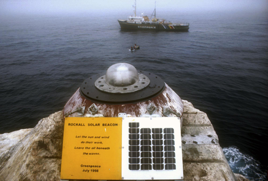
fig. 34 solar-powered navigational beacon fastened on the rock by the Greenpeace in 1998 after another one, repaired by Greenpeace during the 26th and 27th June; the sign:
Rockall Solar Beacon
Let the sun and wind
do their work
Leave the oil beneath
the waves
Greenpeace
July 1998

fig. 35 simplified sketch of the claims on the Continental Shelf of the Rockall Plateau by the United Kingdom (green), Ireland (yellow), Iceland (red) and Denmark (for Faeroes; purple). In 1988, the United Kingdom signed the Continental Shelf Agreement with Ireland, and their common boundaries of the shelf are delimited the yellow-green staircase line (according to the Icelandic serer Utanrνkisrαðuneytið)

fig. 36 the cut-down of the Exclusive Economic Zone of the United Kingdom in the relation to the ratification of the United Nations Convention on the Law of the Sea in 1997; the solid line is the original line, the dashed is the current one (Symmons, 1998)

fig. 37 cut of the map by Mercator Published in Amsterdam in 1618. There are showed (as well as Rockall) also some phantom islands as Brazil, Flandria and Frislandt (by the northern edge)
Text attachments
text 1 Extract from the Fragments of Voyages and Travels by the Captain Basil Hall, published in 1831; passage from the chapter VI. Rockall, in which there is also written about the fist expedition on Rockall. (During that expedition a thick fog came and thus the ship (HMS Endymion) could not be seen from the boats sent to the rock. When the boats managed, at twilight, to reach the ship and when they asked why it was not shot from the board to localize it, the crew answered: Why, we have been doing nothing else but blaze away every ten minutes for these last five or six hours.):
In a fine autumnal morning, just a week after we had sailed from Lough Swilly, to cruise off the north of Ireland, a sail was reported on the leebeam. We bore up constantly, but no one could make out what the chase was, nor which way was she standing at least, no two of the knowing ones could be found to agree upon these matters. Here various opinions, however, presently settled into one, or nearly so for there were still some of the high-spyers who had the honesty to confess they were puzzled.
The general opinion was, that it must be a brig with very white sail aloft, while those below were quite dark as if these royals were made of cotton, and the courses of tarpaulin, a strange anomaly in seamamship, it is true, but still the best theory we could form to explain the appearances. A short time served to dispel these fancies; for we discovered, on running close to our mysterious vessel, that we had been actually chasing a rock not a ship of oak and iron, but a solid block of granite, growing, as it were, out of the sea, at a greater distance from the mainland than, I believe, any other island, or islet, or rock of the same diminutive size, is to be found in the world.
text 2: The Law of the Sea (extract from the United Nations Conventions; some definitions)
(2.1.): according to the United Nations Convention on the Continental Shelf, written in 1958:
Continental Shelf
- sea-bed (and its subsoil) of the undersea areas adjacent to the shore of the state (but beyond the territorial waters), up to 200 m of depth or to the depth (beyond the limit) which allows exploitation of its resources
- every coastal state has exclusive right on the research, exploitation of the natural resources on the sea-floor and its subsoil
(2.2.): according to the United Nations Convention on the Law of the Sea, written in 1982:
Territorial sea
- every State has the right to establish the breadth of its territorial sea up to a limit not exceeding 12 nautical miles
Contiguous zone
- the contiguous zone may not extend beyond 24 nautical miles from the baselines from which the breadth of the territorial sea is measured
Exclusive Economic Zone
- the exclusive economic zone is an area beyond and adjacent to the territorial sea; the exclusive economic zone shall not extend beyond 200 nautical miles from the baselines from which the breadth of the territorial sea is measured
- the coastal state has sovereign rights for the purpose of exploring and exploiting,conserving and managing the natural resources, whether living or non-living, of the waters superjacent to the seabed and of the seabed and its subsoil
Continental Shelf
- the continental shelf of a coastal State comprises the seabed and subsoil of the submarine areas that extend beyond its territorial sea throughout the natural prolongation of its land territory to the outer edge of the continental margin, or to a distance of 200 nautical miles from the baselines from which the breadth of the territorial sea is measured where the outer edge of the continental margin does not extend up to that distance
- outer limits of the continental shelf on the seabed either shall not exceed 350 nautical miles from the baselines from which the breadth of the territorial sea is measured or shall not exceed 100 nautical miles from the 2,500 metre isobath
- the coastal State exercises over the continental shelf sovereign rights for the purpose of exploring it and exploiting its natural resources
- the rights of the coastal state do not affect the Exclusive Economic Zone
- the coastal State shall have the exclusive right to authorize and regulace drilling on the continental shelf for all purposes
High Sea
- the area of water not included in none of above mentioned waters is international in the sense of the rights; none of the state have to right to include it into any of its own zones
Island
- an island is a naturally formed area of land, surrounded by water, which is above water at high tide
- except as provided for in next paragraph, the territorial sea, the contiguous zone, the exclusive economic zone and the continental shelf of an island are determined in accordance with the provisions of this Convention applicable to other land territory
- rocks which cannot sustain human habitation or economic life of their own shall have no exclusive economic zone or continental shelf
From here you can go on the top, or for example on the brief version or on the full version.