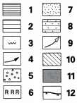
 fig. 14 – Gross depositional environment maps summarizing the main depositional systems existing during the development of the mid- to late Cenozoic megasequences. Key to symbols: 1, mounded, elongate sediment drift; 2, sheeted sediment drift; 3, sediment waves; 4, bottom-current circulation, inferred in (a), present-day in (b); 5, late Eocene–earliest Oligocene lowstand fan; 6, early Oligocene reef; 7, mid-Miocene to Holocene fans; 8, interbedded drift and downslope deposits; 9, sediment-source areas; 10, Inferred land areas; 11, areas of extensive bottom-current erosion; 12, maximum extent of mid- to late Pleistocene ice-sheets. Abbreviations: HS – Hebridean shelf; RT – Rockall Through; IB – Iceland Basin; HB – Hatton Bank; HRB – Hatton-Rockall Basin; RKB – Rockall Bank; GBB – George Bligh Bank; LB – Lousy Bank; AD – undersea mountain Anton-Dohrn; BBB – Bill Bailey’s Bank; FB – Faeroe Bank, FS – Faeroe Shelf; WTR – Wyville-Thomson Ridge; RB – Rosemary Bank; a - Eocene/Oligocene, b – Miocene/Holocene (cited from Stroker, 1998)